Austrian Alps: Top 15 Landmarks

Discover the Austrian Alps’ top natural landmarks, including glaciers, lakes, peaks, and passes, reachable on foot without technical climbing skills

Hero Image

Austria's Alps contain some of Europe's most breathtaking natural landmarksdramatic peaks piercing the sky, pristine glaciers clinging to high summits, crystal-clear Alpine lakes reflecting mountain panoramas, and geological wonders shaped over millennia. These aren't distant viewpoints requiring technical climbing or helicopter access—they're accessible landmarks on established hiking trails that determined hikers can reach on foot.

A mountain trail leading from Hoher Burgstall summit towards Starkenburger Hut in austrian Stubai Alps.
Hut-linked paths allow sustained immersion in big mountain landscapes without technical climbing

Austria by the Numbers

  • 60% of Austria is mountainous, with the Alps covering over 62,000 square kilometers

  • 47 protected nature parks and reserves preserving Alpine ecosystems

  • Over 20,000 kilometers of marked hiking trails crossing every mountain range

  • More than 500 mountain huts providing accommodation along established routes

  • 3 UNESCO World Heritage Sites including the Hallstatt-Dachstein region

This guide presents 15 of Austria's most spectacular sights, all featured on our hiking tours. From glaciated high peaks to pristine mountain lakes and geological wonders, these landmarks represent the finest natural beauty Austria's mountains offer—no technical climbing required, just solid fitness and determination.

Iconic Peaks

Austria's highest summits create the dramatic skyline defining the country's Alpine identity. These four peaks represent the most impressive and accessible mountains featured on our routes—from Austria's absolute highest to distinctive limestone pyramids visible for miles across Tyrol.

Grossglockner image 1

Grossglockner

At 3,798 meters, Grossglockner dominates the Austrian Alps as the country's highest peak, its glaciated north face and distinctive pyramid summit visible across much of Carinthia and East Tyrol. The mountain's isolated prominence—rising 2,400 meters above nearby valleys—creates a profile recognizable from distances exceeding 100 kilometers. While the summit requires mountaineering skills, hiking routes circle the massif providing extraordinary views of Austria's most coveted peak and the 8-kilometer Pasterze Glacier flowing from its flanks.
Featured on our tours: The Glockner Trail, 3-Day Hohe Tauern Hut-to-Hut Hike

Zugspitze image 1

Zugspitze

Standing at 2,962 meters on the Austrian-German border, Zugspitze claims the title of Germany's highest peak. Cable cars from both countries reach the summit, but hiking routes from the Austrian side provide more rewarding approaches through varied terrain. The summit panorama is legendary—over 400 peaks visible on clear days extending across the Northern Limestone Alps, into Bavaria, and south toward the Central Alps. Its position at the northern edge of the Alpine chain creates distinctive views impossible from more southerly peaks.
Featured on our tours: The Zugspitze Hike, The Zugspitze Circuit

Wildspitze image 1

Wildspitze

Wildspitze reaches 3,768 meters, forming the highest summit in the Ötztal Alps and the second-highest peak in Austria. Its twin summits—north and south—are separated by a glaciated saddle, with the southern peak holding the true high point. The standard route from the Breslauer Hut crosses moderate glacier terrain, making it one of the more accessible 3,700-meter peaks in the Eastern Alps. The mountain's prominence and isolation create long-range visibility across Tyrol and into South Tyrol.
Featured on: The Ötztal Trek Highlights

Wilder Freiger image 1

Wilder Freiger

Wilder Freiger reaches 3,418 meters, forming the highest summit in the Stubai Alps with a distinctive twin-peaked profile visible across much of central Tyrol. Its glaciated north face and prominent position above the Stubai Valley create a dramatic backdrop for valley towns. The standard ascent from Sulzenau Hut crosses moderate glacier terrain, making it accessible to mountaineers with basic ice experience, while the circuit trail provides close-range views without technical requirements.
Featured on our tours: Stubai High Trail, Stubai High Trail Highlights.

For detailed information about summit-focused hiking including technical requirements and accessibility, see our guide to the best peaks to visit when hiking in Austria.

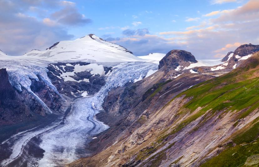
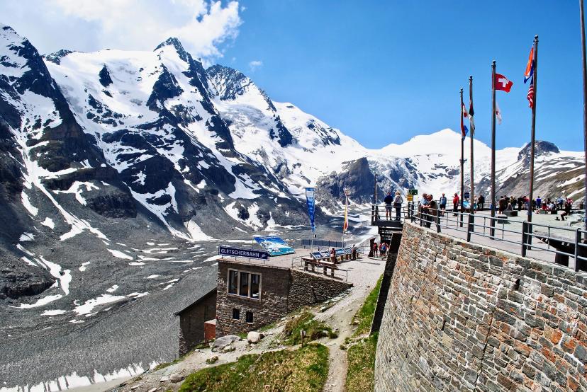
Glaciers & Ice Fields

Austria's glaciers represent the country's most dramatic ice landscapes, remnants of the last ice age still clinging to high peaks despite decades of retreat. These three glaciers are Austria's largest and most accessible, each offering unique characteristics and positioned along established hiking routes.
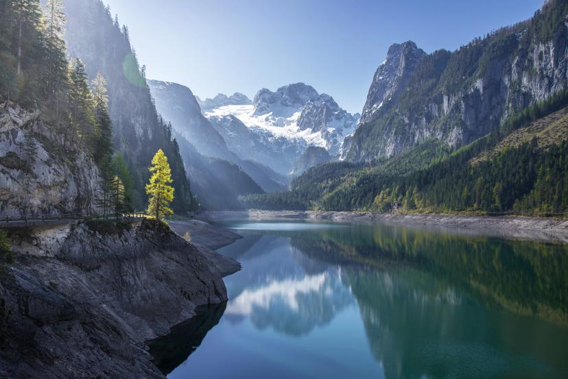
Stubai Glacier image 1

Stubai Glacier

The Stubai Glacier sits at elevations between 2,300 and 3,210 meters, forming Austria's largest year-round ski area at the head of the Stubai Valley. Its network of lifts provides summer access to high-altitude viewpoints across the main Alpine ridge, with the Jochdohle summit platform offering panoramic sightlines toward the Ötztal and Zillertal ranges. Glacial retreat patterns documented since the 1850s make it a reference site for long-term Alpine monitoring. Hiking routes approach the glacier's edge, providing close-range views of crevasse zones and ice falls.
Featured on our tour: Stubai High Trail

Pasterze Glacier image 1

Pasterze Glacier

The Pasterze Glacier extends roughly 8 kilometers down the eastern flank of Grossglockner, making it Austria's longest glacier and the most prominent ice feature in Hohe Tauern National Park. Observation points along the Kaiser-Franz-Josefs-Höhe road allow direct views of the glacier's surface and lateral moraines. Documented retreat since measurements began in the 1850s has reduced its length by over 3 kilometers, providing clear evidence of long-term glacial change. The glacier sits within protected national park boundaries established in 1981.
Featured on our tours: The Glockner Trail, Alpe-Adria-Trail

Dachstein Glacier image 1

Dachstein Glacier

At elevations approaching 3,000 meters, the Dachstein Glacier forms the only permanent ice field in the Northern Limestone Alps, creating a unique juxtaposition of white limestone peaks and glacial ice. Cable car access reaches the glacier's edge, where viewing platforms and the Ice Palace—carved caves within the glacier itself—provide intimate glacier experiences. The ice field's position on pale limestone creates distinctive scenery different from the darker crystalline rock of the Central Alps. Retreat patterns mirror other Austrian glaciers, with well-documented shrinkage providing accessible education about Alpine climate change.
Featured on our tour: The Dachstein Circuit

Alpine Lakes

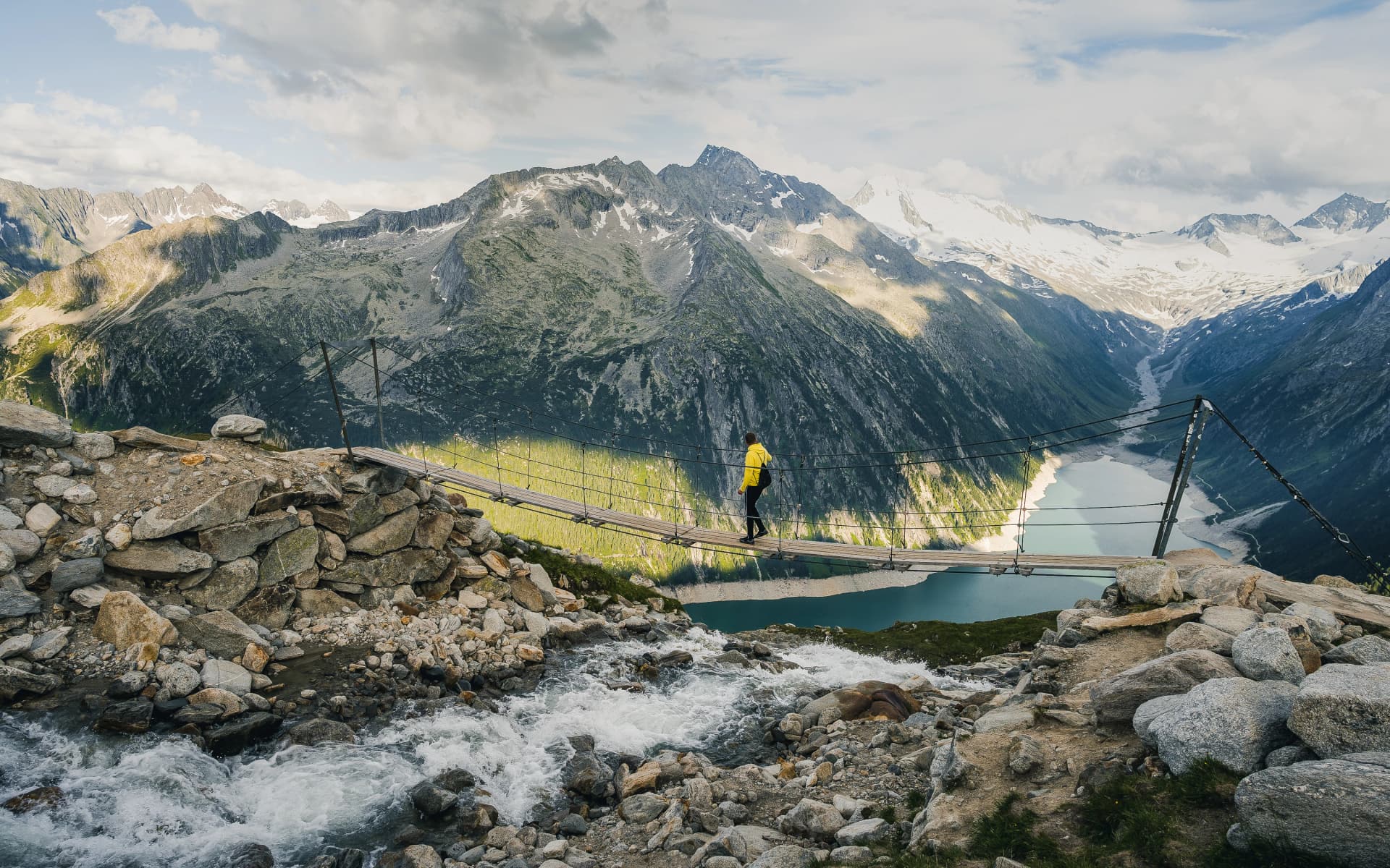
Austria's mountain lakes offer moments of serenity amid dramatic Alpine landscapes, their still waters reflecting surrounding peaks and creating some of the country's most photographed scenes. These three lakes represent different characters—UNESCO cultural landscapes, dramatic cirque settings, and engineering marvels in wild valleys.

Hallstätter See image 1

Hallstätter See

Lake Hallstatt stretches 8.5 kilometers through a dramatic mountain valley, its shoreline village of Hallstatt creating one of Austria's most photographed Alpine scenes with pastel houses reflected in deep blue water. The lake's position between the Dachstein massif and forested slopes creates a microclimate supporting diverse ecosystems. UNESCO World Heritage designation protects both the cultural landscape—reflecting 7,000 years of salt mining history—and the natural setting. Hiking trails circle portions of the lake and climb surrounding ridges, providing elevated viewpoints across the entire basin.
Featured on our tour: The Salzkammergut Lakes Hiking Tour

Gosausee image 1

Gosausee

The Gosausee lakes—Vorderer (front) and Hinterer (back) Gosausee—sit in a spectacular cirque at the base of the Dachstein Glacier, their turquoise water and white glacier backdrop creating arguably the Salzkammergut's most dramatic single viewpoint. The front lake is easily accessible with a flat approach, while the back lake requires a steeper hike into a more remote basin. Water color varies with seasons and glacial meltwater input, ranging from deep blue-green to milky turquoise depending on suspended glacial sediment.
Featured on our tour: The Dachstein Circuit

Schlegeis Reservoir image 1

Schlegeis Reservoir

The Schlegeis Reservoir in the Zillertal sits at 1,800 meters elevation behind a dramatic 131-meter-high dam, creating a striking turquoise body of water surrounded by glaciated peaks. Built between 1965-1971 as a hydroelectric project, the reservoir now functions as both energy infrastructure and a gateway to remote hiking terrain. The dam wall itself offers vertiginous views down the Zamsertal valley and across the reservoir to the Hochfeiler and Großer Möseler glaciated massifs. Hiking routes circle portions of the reservoir before climbing to high mountain huts positioned above the waterline.
Featured on our tours: Routes accessing Zillertal Alps huts

For month-by-month guidance on when lakes and glaciers appear at their most spectacular, consult our guide to the best time to hike in Austria.

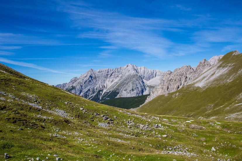
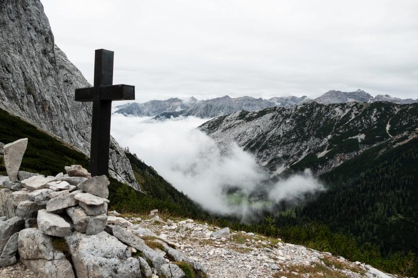
Dramatic Ridges & Passes

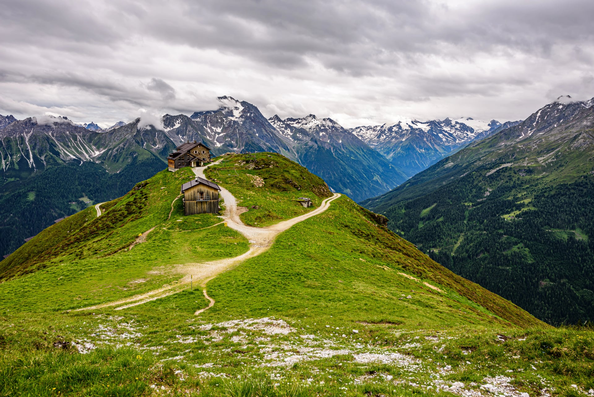
Austria's mountain passes and ridges provide the most dramatic hiking—exposed traverses with soaring views, historic crossing points used for centuries, and modern viewpoints showcasing the Alpine landscape's full grandeur. These three locations represent accessible high-altitude experiences featured on established routes.

Hafelekar Ridge image 1

Hafelekar Ridge

Hafelekar sits at 2,334 meters above Innsbruck, accessible via the Nordkette cable car system that climbs directly from the city center in under 30 minutes. The exposed ridge provides immediate views across the Inn Valley, the Stubai Alps, and the Zillertal ranges without requiring technical alpine approaches. Its position on the southern edge of the Karwendel massif makes it one of the most accessible high viewpoints in the Northern Limestone Alps. The station marks the upper terminus of infrastructure built in stages between 1928 and 2007.
Featured on our tours: Adlerweg Highlights, Innsbruck Sky Trails

Lafatscher Joch image 1

Lafatscher Joch

Lafatscher Joch forms the high point of the Adlerweg Highlights route, a mountain pass at 2,080 meters offering commanding views across the Karwendel Nature Park and south toward the Stubai and Zillertal Alps. The pass sits on a historic mule track carved into limestone years ago, with narrow sections and some exposure requiring sure-footedness. On clear days, visibility extends to Grossglockner—Austria's highest peak—over 100 kilometers distant. The approach from Hallerangerhaus gains significant elevation on steep terrain, rewarding the effort with one of the Karwendel's finest panoramic positions.
Featured on our tour: Adlerweg Highlights

Kaiser-Franz-Josefs-Höhe image 1

Kaiser-Franz-Josefs-Höhe

Kaiser-Franz-Josefs-Höhe sits at 2,369 meters along the Grossglockner High Alpine Road, offering direct views of the Grossglockner summit and Pasterze Glacier from an accessible viewing terrace. The site was developed in the 1930s alongside road construction and named after Emperor Franz Joseph I, who visited the area multiple times during the late 19th century. A visitor center provides interpretation of glacial processes and regional geology. Hiking routes access the viewpoint from surrounding valleys, providing earning-your-view alternatives to the road approach.
Featured on our tour: The Glockner Trail

Natural Wonders

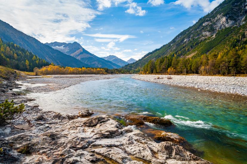
Beyond peaks, glaciers, and lakes, Austria's Alps contain unique geological features shaped by water, ice, and time—waterfalls thundering through narrow gorges, wild rivers flowing unregulated through pristine valleys, and limestone formations creating otherworldly landscapes. These two natural wonders represent exceptional features accessible on hiking routes.

Grawa Waterfall image 1

Grawa Waterfall

Grawa Waterfall drops roughly 85 meters across a 200-meter-wide rock face in the upper Stubai Valley, making it one of the broadest curtain-style waterfalls in the Eastern Alps. A suspended footbridge built in 2006 crosses directly in front of the cascade, providing close proximity to the mist zone and unobstructed views of the falling water. Peak flow occurs during late spring and early summer meltwater periods when glacial runoff maximizes volume. The site sits along marked trails connecting the Stubai Valley floor with higher Alpine zones, making it an accessible highlight requiring no technical skills.
Featured on our tour: Stubai High Trail

Lech River image 1

Lech River

The Lech River flows unregulated through much of its Austrian course, making it one of the last wild Alpine rivers in Europe. Unlike most Alpine rivers channelized for hydroelectric or flood control, the Lech maintains dynamic braided channels, gravel bars, and riparian ecosystems rare in heavily managed modern landscapes. The river's turquoise color—derived from glacial meltwater and limestone geology—creates distinctive scenery as it carves through the Lechtal Alps. Protected status preserves the river's natural character, supporting diverse bird populations and maintaining the hydrological processes that shaped the valley over millennia.
Featured on our tour: The Lech River Trail

For comprehensive route comparisons covering these and other natural landmarks, see our guide to the top 5 treks in Austria.

Austrian Landmarks Await!

These 15 landmarks represent Austria's finest natural spectacles accessible on hut-to-hut hiking routes. Most hikers experience 3-5 of these destinations on a single week-long trek, with longer routes covering multiple categories and diverse landscapes.

Browse all Austria hiking tours to find routes featuring these landmarks, or get in touch to discuss which destinations match your hiking goals.

Agent profile picture
Talk to our travel expert
VALUE YOUR TIME

VALUE YOUR TIME

With everything on your plate, let us handle the vacation planning, so your valuable time stays exactly where you need it.

TRIED & TESTED ADVENTURES

TRIED & TESTED ADVENTURES

Only the best hut to hut hikes of Austria, cherry-picked by our local team with an in-depth knowledge of the region.

TRUSTED BY MANY

TRUSTED BY MANY

We are a financially protected company operating since 2014, and with thousands of satisfied customers in the past, we still put you first.

SELF-GUIDED TRAVEL

SELF-GUIDED TRAVEL

Explore independently and with confidence while we keep everything running from behind the scenes.

OUTDOOR SPECIALISTS

OUTDOOR SPECIALISTS

We are a team of outdoor specialists equipped with the knowledge and insight to bring you the best hiking experiences.